Coastal Management
The City has been successful in securing a number of grants to undertake a range of coastal management activities in response to the ongoing risks presented by coastal erosion.
As part of the monitoring work being undertaken, the City has installed buoys to monitor marine tides, mapped coastline movements and surveyed beach profiles at numerous locations along the coast. Multiple projects are planned, with the goal of implementing engineering solutions to rehabilitate a number of dunes, coupled with the replacement or upgrade of other coastal infrastructure to protect against further erosion.
The City has been successful in securing two different Federal grants from the Department of Industry, Science, Energy and Resources - CERMP (Coastal and Estuarine Risk Mitigation Program) and PACP (Preparing Australian Communities Program).
Coastal and Estuarine Risk Mitigation Program (CERMP)
The CERMP funding has been received for two projects:-
1. West Busselton Coastal Stabilisation
The aim of the infrastructure project was to provide longer term coastal protection to mitigate the impacts of coastal hazards along the coast between King Street and Gale Street in Busselton. The construction included a series of new Geotextile Sand Container (GSC) groynes and sand nourishment.
The low-profile groynes will provide stabilisation to the West Busselton coastline and limit the erosion of the established vegetation and potential loss of the coastal road. This technique is used widely by the City of Busselton along the Geographe Bay foreshore.
The works will be undertaken in two stages as summarised below: -
Stage 1 - Groyne 4 to Groyne 7 (Margaret Street) – Coastal Stabilisation Works
The works will include the following activities: -
- Construction of 4 low profile GSC Groynes, typically of 40m length.
- Beach nourishment with imported sand (7,500m3).
- Refurbishment of the King St GSC revetment (~60m length).
Stage 1 works have now been completed.
Stage 2 - Groyne 1, 2 and 3 (Gale Street) – Coastal Stabilisation Works
The works will include the following activities: -
- Construction of 3 low profile GSC Groynes, typically of 40m length.
- Beach nourishment with imported sand (3,000m3).
- Beach cleanup.
Stage 2 works were completed in March 2026.

Frequently Asked Questions - West Busselton Coastal Stabilisation
Why do you need to do the works?
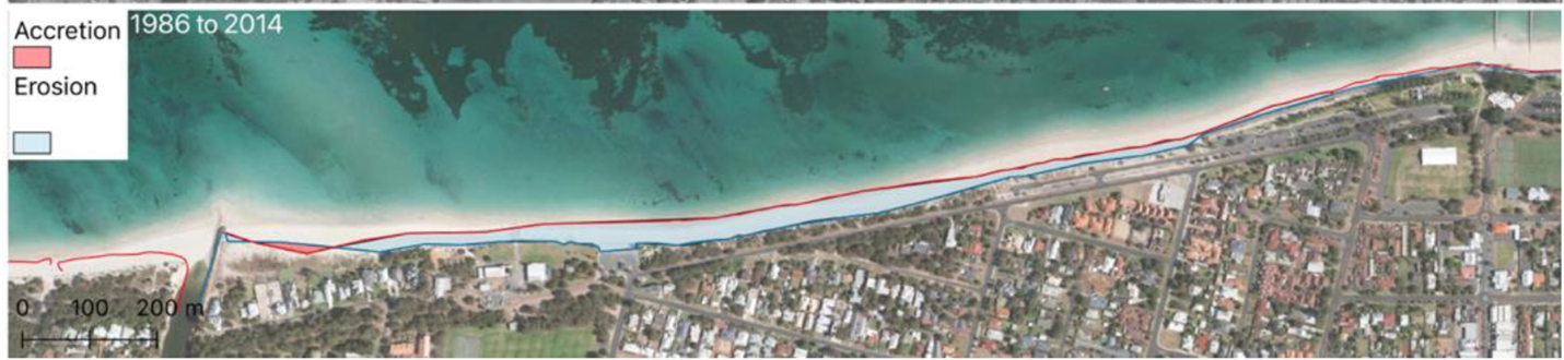
The West Busselton foreshore adjacent to King Street was identified as a coastal erosion hotspot in 2019 as a part of an Assessment of Coastal Erosion Hotspots in Western Australia.
The West Busselton foreshore has been subject to increasing erosion pressure over the past 20 years. Beach amenity is poor with the failure of a concrete boat ramp and rock seawall in recent years, and limited beach width at high tides. There are very narrow buffers to assets including carparks and the coastal road.
Coastal monitoring using high resolution survey identified the erosion of 140,000m3 of sand from the dunes, beach and nearshore areas between Gale Street and Vasse Drain over the last 15 years. This is equivalent to about 7,000 semi- trailer truck loads of sand.
Historic aerial photography also identified shoreline erosion rates exceeding 0.5 meters per year.
Coastal adaptation works are required to mitigate beach erosion necessary to stabilise the coastline, reduce erosion, and protect infrastructure and public safety into the future.
Isn't coastal erosion a natural process we should leave alone?
If the area is left unmanaged, erosion will continue, reducing beach amenity, eroding dunes and putting key public infrastructure at risk. There is an increasing risk to assets from coastal erosion including the Busselton Fitness Club Inc carpark, Geographe Bay Yacht Club, public open space, landscaped areas at King Street, the dual use path (DUP) and the carpark and road west of Gale Street.
The City of Busselton undertook a resident survey in June 2020 as a part of the Busselton Coastal Management Program (2021 -2031). The “management and protection of our coastline from erosion” was identified as the most important issue by City of Busselton residents.
What other options were considered?
Coastal adaptations considered by the City at West Busselton included sand nourishment/beach scraping, groynes and seawalls.
In recent years beach erosion has been managed with beach scraping and sand nourishment. However, with the failure of the rock seawall and boat ramp, increased sand supply costs and high rates of erosion, this option was not considered to be effective in the long term.
Coastal revetments were considered but due to the long-term sediment deficient, there was a concern this would result in loss of the sandy beach in front of the seawall at this location, without coastal stabilisation structures.
What about offshore reefs for coastal stabilisation?
Offshore reefs can provide some degree of coastal stabilisation at some locations. However, they generally need to be relatively large and high to stabilise the adjacent beach as a salient. They are a higher cost structure and more difficult to design and to construct than groynes.
Submerged ‘multi-use’ reefs can have additional amenity benefits (e.g. Albany artificial surfing reef), but are offshore and submerged with limited coastal stabilisation benefits.
What are the groynes made of?
The groynes will be constructed using Geotextile Sand Containers (GSCs) like the largely buried structures at the Busselton Jetty. These structures are designed to blend into the beach environment, are less visually intrusive than traditional rock groynes, soft underfoot, and are partially buried to maintain beach amenity.
I've seen groynes cause erosion before in Busselton, will these do the same?
Groynes can lead to downdrift erosion in Geographe Bay, particularly long structures (e.g. Siesta Park groyne constructed in the 1960s).
The groynes at West Busselton are designed to be low-profile and relatively short to balance ‘updrift’ sand trapping and ‘downdrift’ erosion. Groynes are seeded with initial sand nourishment to limit capture of the natural littoral drift of sand along the shoreline.
Similar groyne fields have been constructed east at the Busselton Jetty (2009), East Busselton (2012) and West Abbey (2024) and have been effective.
Coastal monitoring of the beaches either side of the works will be undertaken as part of a wider 10 year Coastal Management Plan for Geographe Bay following construction.
Why don't you build in winter?
Winter is typically when storms and high water levels are most frequent. Undertaking coastal construction at West Busselton in winter was not feasible due to narrow beach widths, high tides and the risks of storms damaging the works.
Will the public be able to access the beach during the works?
The public will be able to access the beach either side of the works.
There will be a temporary closure of the King Street carpark from mid-October through to December. Parking will be available nearby adjacent to Lou Western oval and beach access to the west. Clear signage and alternative access paths will be provided.
2. Vincent Street Seawall Refurbishment
Over the past 15 years the foreshore at Vincent Street and Bayview Crescent in Dunsborough has experienced erosion. Beach erosion has weakened mature peppermint trees, steps and pathways, exposed the damaged revetments (large rocks placed along the foreshore to protect against erosion) at the northern end of the beach and stormwater outlets, and threatened to erode the dual use path.
The original revetment at Vincent Street is now in poor condition and needs maintenance. The proposed refurbishment (along with increasing sand volumes and dune stabilisation work) forms part of the City's program to manage the foreshore.
Proposed Coastal Adaptation Works at Dunsborough include:
- Maintenance of Existing Rock Revetments:
- Vincent Street: ~150 meters of existing retaining rock to be maintained.
- Bayview Crescent: ~150 meters of existing retaining rock to be maintained.
- Dune Resilience Works:
- Build a wider, stabilised dune at Vincent Street to act as a natural buffer against erosion.
- Beach Nourishment:
- Add sand to widen the beach at Vincent Street
- Optional Granite Outcrops (Subject to Community Consultation):
- Install granite outcrops for moderate protection of the beach
Community Consultation Update
Thank you to everyone that took part in the recent community consultation on the Dunsborough Foreshore Coastal Adaption Works. Following community feedback, the preferred revetment option was granite- weathered face exposed (varied grey and brown faces), reflecting a shared desire to retain the natural coastal character of the area. There was also support for the proposed installation of three granite outcrops along the Vincent Street and Bayview Cresent Foreshore as part of ongoing coastal erosion management, with 63.4% of respondents in favour.
Works are expected to commence in late 2026. For further information on the consultation, visit
Your Say Busselton >>
Preparing Australian Communities Program (PACP)
The City of Busselton was also successful in securing $3,532,500 grant funding in July 2022 from the Department of Industry, Science, Energy and Resources (Federal) – National Emergency Management Agencies (NEMA) – funding program Preparing Australian Communities Program (PACP).
This funding was secured for the Geographe Bay Coastal Mitigation Works Project, which is co-funded by the City of Busselton from its Coastal and Climate Adaptation Reserve resulting in a total project budget of $7,065,000 to be implemented over four budget years.
This project is currently in year three of four of its implementation.
This infrastructure project is anticipated to improve the resilience of the community to flood and tropical cyclone in the social, economic, natural, and built environments by mitigating the risk of coastal flooding associated with tropical cyclone storm surges through emergency planning, impact modelling, dune resilience works and construction of coastal flood mitigation structures in Busselton.
The project outcomes are as follows:
Emergency Response Plan
A multi-agency steering group was established for the Preparing Australian Communities Program (PACP) in August 2022.
The City has established Local Emergency Management Arrangements, delineating the responsibilities of various agencies in responding to emergencies within the region, encompassing a diverse array of hazards.
An anticipated outcome of the PACP project includes the updated mapping of the storm surge hazard for Busselton, scheduled for completion by mid-2024.
Wave buoys have been installed in Geographe Bay since 2022 to allow real-time monitoring of storm events. Tide gauges to measure storm surge in real-time are planned to be installed in Dunsborough and the Busselton Jetty in 2024.
Coastal Investigations (Flood Modelling)
The Coastal Investigations component of the project is progressing.
A targeted oceanographic monitoring program (water levels and waves) was completed in 2024, to better understand storm surge behavior in Geographe Bay, and provide a data set for validation of numerical models.
Coastal modelling works have been completed by an external consultant across five stages:
- Stage 1 - Tropical Cyclone Modelling
- Stage 2 - Dune Erosion Assessment
- Stage 3 - Coastal Inundation Modelling
- Stage 4 - Interaction of Coastal and Catchment Flooding
- Stage 5 - Mitigation of Coastal Inundation
Dune Resilience Works
Planning, design, and approvals are well underwayfor the dune resilience works.
Environmental surveys (vegetation mapping and fauna surveys) were undertaken by an external consultant in 2023. A Coastal Survey was also utilised to allow development of a coastal vegetation map of the dunes along Geographe Bay, to better understand resilience to storm surges, and plan mitigation works.
Vegetation surveys have been undertaken at two trial sites proposed for Dune Resilience Works (Stage 1) in Abbey and Broadwater.
Dune Resilience Stage 1 was completed in West Abbey and Broadwater in July 2024.
Stage 2 works are planned for November 2024 – April 2025, with the location of the works determined by coastal modelling and lessons learnt from Stage 1 works.
Further information on Stage 1 can be found below.
Coastal Flood Mitigation
The design of Coastal Flood Mitigation works commenced in July 2024. Design and construction of coastal flood mitigation works will be based on recommendations of the coastal investigations (flood modelling). These works include raising drain embankments, stormwater non-return valves and coastal levees (Stage 2 works) to mitigate risk of coastal flooding in low lying areas.
More information on Stage 2 is shown below.
There were two stages to these works, as outlined below:
Stage 1 Dune Resilience Works
The proposed Stage 1 Coastal Dune Resilience works were undertaken in May/June 2024 in West Abbey and Broadwater. East Abbey Groyne Repair works were scheduled for later in 2024.
West Abbey Coastal Dune Resilience
The work scope was to rebuild eroded coastal dunes west of the boat ramp that collapsed during storms in May 2020, that will provide a natural buffer to coastal inundation. The Dune Resilience Works were undertaken over a narrow 0.4ha area west of the Abbey Boat ramp.
The works at West Abbey included:
- Communication with residents regarding planned works
- Demarcation of the work site to protect adjacent coastal vegetation and for public safety
- Carting and placement of a mix of imported and local sand as a series of dune ridges and swales
- Planting coastal dune seedlings
- Installation of beach access matting over the dune whilst the planting gets established
Broadwater Coastal Dune Resilience
These works include the construction of new coastal dune ridges across a potential flood pathway to provide a natural buffer to coastal inundation. The Dune Resilience Works were undertaken over a 0.96ha area West of Dolphin Road boat ramp.
Works were completed in May/ June 2024 to take the opportunity of early winter rains and to increase the survival rate of dune seedlings.
Beach sand for dune rebuilding was imported to the dunes and relocated from adjacent beaches where ongoing accretion occurs. Selective planting of native species will be undertaken to both increase the resilience of the dune surface to erosion, and to restore or enhance the ecological function of the coastal dune habitat.
East Abbey Groyne Repair Works
This groyne is a critical piece of coastal protection structure, but it is now damaged and in need of replacement. The City will be removing the timber groyne and replacing it with a new geotextile sand container groyne in the same location to the east of Abbey Boat Ramp. This will be a ‘low profile’ groyne to allow sand to naturally bypass and to ensure there is a minimal impact to the beach environment and amenity. This will be similar to the geotextile sand container groynes that have been constructed west of the boat ramp in recent years.
Additional Information
Coastal Inundation Sketches 1 - Dune Resilience
Coastal Inundation Sketches 2 - Dune Resilience
Stage 2 Dune Resilience Works and Coastal Flood Protection Levees
The below works have now all been completed.
1. East Busselton Coastal Paths and Dunes
The scope of works includes the following:-
- Dune Resilience Works (Ford Rd to Freycinet Dr) – Construction of stabilised coastal dunes in the foreshore reserve.
- Coastal Path Refurbishment – Levee (Wakeford St to Morgan St) – Refurbishment of low-lying sections of the coastal path to improve capacity to mitigate coastal flooding and widening to improve amenity (multi-purpose structure).
Please refer to Annexure A – for a copy of the Drawings of the proposed works.
All of the below works have been completed:
- 30,000 low-growing native shrubs and groundcover were planted.
- Construction of stabilised coastal dunes in the foreshore reserve completed.
- Coastal path refurbishment has been completed.
2. West Busselton (Vasse Drain) Coastal Path and Dunes
The scope of works includes the following:-
- Dune Resilience Works (Margaret St) – Construction of stabilised coastal dunes in the foreshore reserve.
- Coastal Path Refurbishment – Levee (Vasse Drain) – refurbishment of the coastal path along the eastern side of the Vasse Drain Diversion to improve capacity to mitigate coastal flooding and widening to improve amenity (multi-purpose structure).
Please refer to Annexure B – for a copy of the Drawings of the proposed works.
All of the below works have been completed:
- Dune stabilisation has been completed and biodegradable matting for added protection has been installed.
- 7,000 low-growing native shrubs and groundcover have been planted.
3. West Busselton (Dolphin Road) Coastal Path, Dunes and Drainage Outlet
The scope of works includes the following:-
- Dune Resilience Works (Dolphin Rd) – Construction of stabilised coastal dunes in the foreshore reserve.
- Coastal Path Refurbishment – Levee (Dolphin Rd and Craig St) – refurbishment of the coastal path along the eastern side of the Vasse Drain Diversion to improve capacity to mitigate coastal flooding and widening to improve amenity (multi-purpose structure). This includes a vehicle cross-over at the boat ramp approach.
- Drain Outlet (Silverglenn Ave): Extension of stormwater outlet with non-return valve, headwall and levee bank.
Please refer to Annexure C – for a copy of the Drawings of the proposed works.
All of the below works have been completed:
- Works are complete, with a few works still underway, including: furniture installation and clean-up.
- 2,500 low-growing native shrubs and groundcover planted.
- Dune stabilisation has been completed and biodegradable matting for added protection has been installed.
- Coastal path refurbishment has been completed.
- The extension of a stormwater outlet has been completed.